catalogue data.grandlyon.com
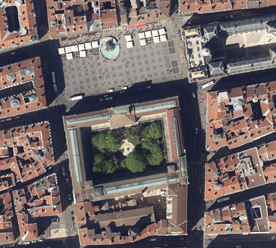
Orthophotographie 2018 de la Métropole de Lyon
Orthophotographie de 1 400 km² sur la Métropole de Lyon et ses environs.
La visualisation utilise une image au pixel de 0,16 m.
Le tableau d'assemblage permet de localiser les 64 dalles de 25 km² (selon le quadrillage RGF93 CC46) au pixel de 0.08 m.
Simple
- Date (Creation)
- 2022-03-21
- Identifier
-
eed2c73c-6d5f-4160-a1c1-2b4b1d368c86
-
GEMET - INSPIRE themes, version 1.0
-
-
Étendue géographique des données
-
- Theme
-
-
Ortho-imagerie
-
Imagerie/Cartes de base/Occupation des terres
-
- Access constraints
- otherRestrictions Other restrictions
- Spatial representation type
- vector Vector
- Metadata language
- freFrançais
- Topic category
-
- territoires-infrastructures
- OnLine resource
-
ortho_2018
(
OGC:WMS
)Orthophotographie 2018 du Grand Lyon
- OnLine resource
-
ortho_2018
(
OGC:WCS
)Orthophotographie 2018 du Grand Lyon
- Hierarchy level
- dataset Dataset
- Statement
-
Prise de vues aériennes par caméra numérique, du 17 au 20 avril 2018.
- File identifier
- eed2c73c-6d5f-4160-a1c1-2b4b1d368c86 XML
- Metadata language
- freFrançais
- Hierarchy level
- dataset Dataset
- Date stamp
- 2019-08-15
- Metadata standard name
-
INSPIRE Metadata Implementing Rules
- Metadata standard version
-
Technical Guidelines based on EN ISO 19115 and EN ISO 19119 (Version 1.2)