catalogue data.grandlyon.com
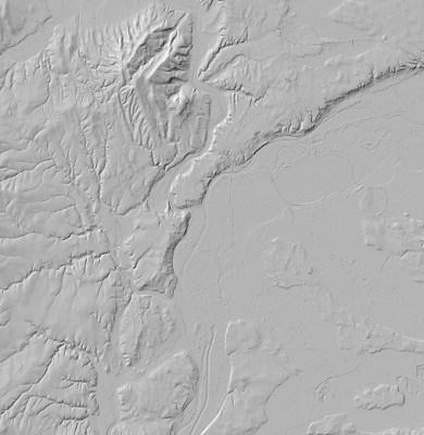
Ombrage du relief 2018 de la Métropole de Lyon (format TIFF)
L'ombrage du relief est une image en niveaux de gris, calculée à partir du modèle numérique de terrain (MNT) raster.
Simple
- Date (Creation)
- 2022-03-21
- Identifier
-
2d64f3d4-e66f-4ec7-9316-7d947d453c06
-
GEMET - INSPIRE themes, version 1.0
-
-
Étendue géographique des données
-
- Theme
-
-
Altitude
-
- Access constraints
- otherRestrictions Other restrictions
- Spatial representation type
- vector Vector
- Metadata language
- freFrançais
- Topic category
-
- territoires-infrastructures
- OnLine resource
-
MNT2018_Ombrage_2m
(
OGC:WMS
)Ombrage du relief 2018 de la Métropole de Lyon (format TIFF)
- OnLine resource
-
MNT2018_Ombrage_2m
(
OGC:WCS
)Ombrage du relief 2018 de la Métropole de Lyon (format TIFF)
- Hierarchy level
- dataset Dataset
- Statement
-
Calculé à partir du modèle numérique du terrain (MNT) raster
- File identifier
- 2d64f3d4-e66f-4ec7-9316-7d947d453c06 XML
- Metadata language
- freFrançais
- Hierarchy level
- dataset Dataset
- Date stamp
- 2019-03-25
- Metadata standard name
-
INSPIRE Metadata Implementing Rules
- Metadata standard version
-
Technical Guidelines based on EN ISO 19115 and EN ISO 19119 (Version 1.2)